Wing Ng has made mention, to those who care to listen, of HTMC members of yore who used to descend to the windward side from Mount Olympus as a daredevil initiation ritual. More recently, some daredevil wannabes have tried to climb to Olympus (aka Awa'awaloa) from the Maunawili by two different routes, only to be stymied by steep, dangerous conditions.On Saturday 10/26/02, Ed Gilman and I try a third route, and after a taxing and at times nerve testing seven-hour effort, we achieve the goal.We drive in my car to the Maunawili Falls starting point on Kelewina Street and shove off at just past 8 a.m. under partly cloudy skies. With just a tad of dampness underfoot, Ed and I hike up past the junction with the falls trail and onward up the connector trail that eventually merges with the Demonstration Trail at about the 2 to 2.5 mile mark.At that point, we head left (east) on the demo trail to get to the base of our target ridge. We see the object of our attention at various points on the way. It looks challenging, even menacing, but we will give it a shot. We meet some hunters with their dogs en route. By chance, Ed knows one of the hunters from a meeting this past Wednesday while hiking in Pia Valley. It is an interesting coincidence that they meet again today on the other side of the island.
 |
| Pic 1 -- by Dayle Turner |
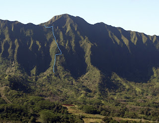
We arrive at the start of our target ridge after a 1.5 hour hike from Kelewina Street. We don't mark the spot; we just plow up (see pic 1) mostly thru fiddlewood and uluhe. We both are wearing long pants. In hindsight, I wish I had worn a long-sleeved shirt, for my forearms and elbows end up scratched up quite extensively from hours of fending off and pushing aside thick vegetation. Within five minutes of climbing, we come upon a wire basket on the ground with small pots in it. This has to be for pakalolo though the plants in the pots don't look like pot. Not interested in the pakalolo, we keep plowing upward, again mostly thru uluhe then soon come upon another 3 to 4-foot plant that looks like pakalolo. Not sure if it is. Doesn't smell like it. With my disposable cam, I snap a pic for the flora experts to examine and render a decision.We keep climbing and I notice, to my disappointment, that my altimeter watch is giving bogus elevation readings. That is, it says we are at ~100 feet when the map says we should be 1000 feet higher. Chagrined, I hope it corrects itself and later, thankfully, it does. As we climb, we have a great vantage point to look to our right to see the ridge we tried on our last attempt and in particular the rockface that turned us back. The face looks crazy. Insane. Why did we even attempt that? I snap a couple pics of it. Hope they come out.Today's ridge is much saner, at least until we reach the 1600-foot level. At that point, my altimeter watch kicks in and starts giving more believable readings. Glad for that. Not glad that we have reached a vertical wall that will not allow us to continue straight up climbing due to impossible steepness. Ed suggests a rightward slab, and we move along cautiously, progressing slowly, machetes swinging, with a thick patch of clidemia and vegetation shielding us from a steep dropoff below it. After about 100 feet, our slabbing becomes more precarious when the patch of protective vegetation thins. Ed is in the lead during the slab and after weighing the situation (vertical exposure below with not much of hand- and foot-holds to work with) and a nasty possible consequence (falling a long way), he decides to retreat. I support his decision without question.We backtrack, regroup, then try a straight up ascent, only to be stifled by the steepness and lack of good holds. We retreat again, bummed.At that point, heading back down and calling it a day is a possibility. However, we talk about setting up a belay on Ed and having him try the rightward slabbing move one more time, this time with protection. Ed says okay to this and we proceed with the set-up.The belay, anchored to a sturdy ohia, is established and with it, Ed moves across the exposed position with confidence, making it look easy.Okay, my turn. Ed ties off his end of the 50 to 60 foot strap, and with my end tied off, there is now an aid in place for me to make my way across. I make my move and as I near the far end, a foothold I am on gives way, and I go sliding down the exposed section but am saved, thankfully, by the strap and the grace of God.God is with me, as is the strap, and I hold on, say a quick prayer, and am able swing myself up to the strong roots and branches of an ohia. From there I am able to climb to safety. Whew. Close call. Amen.Having completing the slab, we now have positioned ourselves in a good place to continue climbing. We have a distinct ridge to work with again, albeit a thickly overgrown one, predominantly with i'e i'e. On this day, I do not curse the vegetation. Why? It helps to protect us. Without it, we are stripped of the cover we need from steep dropoffs. Without it, we have no hand- and footholds to pull ourselves up. Without it, we would not have completed the climb.As we do all day, Ed and I rotate into the lead position to conserve energy and sanity. Whoever is in front has to expend more firepower to fight thru tangles of i'e i'e and clidemia and other kinds of thick flora. This isn't to say the second guy has an easy time. Far from it. It's just that the front guy has to battle harder because there is no swath to work with. None. Nada. Zip. Zilch. So swapping the lead is the way to go. As always, Ed does his share with nary a complaint. Hats off to him. An excellent hiking colleague.The going is painfully slow, so much so that after the slab & belay point, we only gain a couple hundred vertical feet over the course of 1.5 hours. As 1:00 pm nears, we are still battling vegetation but thankfully the angle of ascent lessens and we hunker down at a fairly level spot on the ridge for lunch. My altimeter watch says we are at 1800 feet, still about 600 vertical feet from the summit crest. As we eat lunch (see pic 2--the red dot in the pic, which is taken from the summit, is where we ate lunch), it's easy to see that we both are angsted. We don't talk much and I don't feel like eating much, the latter being very unusual for me.
 |
| Pic 2 -- by Dayle Turner |
I suppose we are not our chipper selves because we know we still have the unknown ahead of us. We can see that more severely steep climbing is ahead and there is the chance we will be stopped by the steepness and will have to retreat. That map shows this is possible. So does the view ahead. We are nervous. Again, I say a prayer.After lunch, after about ten minutes of climbing, we finally break free of the vegetation to gain a vantage point with an unobstructed view of the final ascent to the summit. It looks daunting: a huge wall, with no apparent ridge, that is steep 80% of the way and super steep in the final 20%. Can we climb this? Should we even try? Or should we just toss in the towel and head back down?We know that sometimes what appears horrid turns out to be not so bad once we are up close and face to face with it, so we mush ahead, hopeful that what we see from a distance will turn out to be not bad at all once we are on it.Luck and God are with us today. The steep wall we face is indeed steep. But the climbing is doable because the vegetation, clidemia by and large, is so thick. The dense thicket we climb up thru is like a womb to protect us, not only from the drops but also from views of the drops. Enveloped in the clidemia, we plow upward like babes in the arms of our mothers and make good progress.As we climb ever upward, we can see that we will eventually have to slab to the left or right because straight up climbing will become impossibly steep within 100 feet of the top, we choose a leftward slab because a shelf is visible there. This shelf pans out well for us, and we follow a good line that moves us leftward and gradually upward toward our goal, the summit.As we are slabbing, we catch a view of the ridgetop, a tantalizing twenty feet above us. Overjoyed, we climb toward it, passing a couple of healthy lobeloids growing on the steep mountainside. I think of Ken Suzuki and make a mental note to make mention of this sighting. We get close to the ridgetop only to be thwarted by near vertical steepness and a lack of reliable holds in the final ten feet. It seems that the thick vegetation we have relied on all the way has turned fickle right at the top. Ed tries to climb the final couple meters but within an excruciating few feet of the top, he decides not to chance it due to very bad foot- and handholds. I see Ed voice frustration for the first time ever.We retreat and regroup. He and I sit for a while to gather ourselves and ponder our next move. I have fleeting thoughts that we will be denied so close to the top and will have to head back down. Ed, meanwhile, suggests continuing to slab to the left to try to hit the ridge at a lower point. I agree hesitantly because continued slabbing to the left means increased exposure to dropoffs. Ed leads and contours gingerly on a thin shelf with not much stable nor strong vegetation to work with. Based on a suggestion by Ed, I slab on a line about ten feet lower.After some nervous moments (mostly for me), Ed completes a nifty move to get to a secure position; then he climbs up a small chute to gain the summit!! A minute later, I complete my slab then wiggle and claw my way up the chute and I too am at the top. It is just past 3:00. The climb, which a map review says is less than half a mile, has taken us 5.5 hours!We shake hands and congratulate each other, for completing the climb and for not injuring ourselves (or worse) while doing so. Probably because I have spent hours clinging to vegetation with a vice grip, my right hand cramps and is stuck in a closed-fist, grasping position. I've never had that happen to me before. Never have done a climb like today's before either.Handshakes and congrats out of the way, we sit down to rest on our summit ridge perch. I am almost out of water (I start with four liters) and Ed gives me a liter of his. I feel much better after downing the H20 and my hand cramps subside. A bit east of where we have summitted, I snap some pics of the ridge and steep area we have climbed. From the top, our up-route looks crazy and Ed and I wonder aloud how and why we have climbed what looks suicidal.
 |
| Pic of slab route -- by Dayle Turner |
I must mention that we have topped out not on the summit of Olympus (elev 2486), but in a low saddle area to the Makapu'u (east) side of it. My altimeter watch is reading 2280 at our top-out point. The demo trail is at ~900 feet so the total gain is about 1400 feet.During our rest, we decide going back the way we've come up is not an option, so I make a call on my cell phone to my ku'uipo and she agrees to come and pick us up in Manoa. She says she will be waiting for us at 4:30. At couple minutes later, my cell phone rings but I fish it out of my pack too late to answer it. Listening to the message, I find out the call is from Saxman Scott (Villiger) who is over on Mount Olomana and looking mauka at Olympus. He is wondering how we are doing and wishes us well.Also during our rest, I look up at the steep climb we will have to make to get to Olympus and realize we have another option to get back to civilization, namely the trail down the west rim of Ka'au Crater, which is about a 15-minute hike away along the summit. Ed isn't opposed to this option, so the Ka'au Crater west descent it will be. I call Jacque to tell her of our revised plan.
 |
| Dayle Turner -- photo by Ed Gilman |
Tired but euphoric, Ed and I head east across the summit, negotiating a couple of humps along a mildly overgrown trail. We then hike down Ka'au's west rim trai, also mildly overgrown, then continue down the switchback trail to reach the path along Waiomao Stream. We reach the trailhead at the end of Waiomao Street at just past 4:30, ending a 1.5 hour descent from our top-out point. Within five minutes of our arrival, Jacque pulls up to drive us back to Maunawili. Great timing and great to see her though she balks at hugging me because of my sweaty, dirty state. I do not blame her. "You folks look terrible," she says to Ed and me. We laugh, knowing we do and that we probably smell worse.So ends a tough grinder of a hike with two dangerous spots.


Comments
Post a Comment