 |
| Photo by Oahuhiker |
Hike date: 6 June 2010, Sunday
Since I had to work on Saturday (National Trails Day) I figured I would make up for it on Sunday by adding a fourth option to the Aiea trail network: a windward continuation.After months of putting it off, yesterday became the day for a summit attempt of this obscure windward ridge. I had been looking for a new route on that side and spotted a ridge that begins behind Ahuimanu and climbs to a peak north/west of the Aiea Ridge terminus. This ridge is fairly prominent, and is between "Ulupaina Uka" to the south and "Kalahaku Teeth" to the north.A little history:
My initial scouting trip began from a poor access point, but subsequent clearing trips began from an access point at the end of Heno Place - ~300 ft elevation where I parked, just down the road. I believe this might be the access for the Ahuimanu trail that the Club uses to get to the waterfall. I have never joined them for this one, but the trail is wide and well ribboned.After a several hours of exploration on my inital outing, I found that the much more subtle ridge just south (to the left) of the prominent one would be the way to go. It already had a swath leading up a broad uluhe slope and it was closer to the trailhead. (From the trailhead, you are on the main trail for less than 5 minutes before turning right on the "Uka" trail. Look for my pink ribbons.) The ridge I would decide on becomes quite steep - and exposed in places - but unlike the neighboring prominent ridge it did not have any notches. My route would be a consistent uphill battle.My last two visits here - a few months back - were short trips to blast open the uluhe swath, hang ribbons through the valley section below it, and assess the exposed part I could see from the road below. Machete work made me a nice corridor through the uluhe and I would have a more pleasant start on summit day. Whoever had been using this swath on the lower part of the ridge must have stopped shortly after the uluhe as I would not see any signs of trail or travel after ~800-900 ft elevation. And not surprisingly. It was around this elevation that the ridge narrowed considerably, and became a steep climb on very brittle rock using scattered "trumpet" trees as handholds. Two prior visits ended at 900 ft when I was doubtful of further upward progress at one particular spot with no trees to grab. This climb will make a monkey out of you as it involves a lot of upper body effort.Yesterday:
Loaded down with over 200 feet of strong rope, I hit the trailhead just before 9am. It was cloudy up top, nice down below, and I thought I had a chance of the summit clearing up. (Wrong.) In roughly 45 minutes I was at my prior trouble spot at 900 ft. Taking a chance (knew I had the rope in case I needed to get down) I was able to claw my way up to a higher spot. Rocks were being dislodged, but I was confident that no one was in the impact-zone below. I quickly reached a place that was even more tricky. I tried to climb up the right side, but rotten rock and poorly rooted trees meant I would struggle for about 15 minutes. Several times I would get near the next handhold...only to have something give way and send me sliding back down in a hurry. One notable drop was about 10 feet, and I was lucky to catch the (only) trumpet tree with my left foot. But I remained determined, and was eventually able to finesse my way to a more secure spot.A look to my left reassured me that I was making progress upwards. It also remined me of why I was NOT climbing THOSE ridges. Looked like Kalalau. As I got higher still, I reached a spot where it leveled off momentarily and I could admire the views both left and right. On the right was the prominent ridge that I was paralleling. You can see the second notch - the smaller and higher of the two notches - in this photo. As I got higher, I would intercept this ridge, labeled as "Junction" on my last photo.
 |
| Photo by Pete Clines |
After 1000 ft, I was on a short section that reminded me of the narrow dikes on the cemetary route to Manamana. Higher still and I started to find myself in the clouds. Bummer. I would get no views - or photos - after about 1400 ft. The exposure and danger of the ridge was now replaced by a very overgrown route and super-slow progress. I was struggling to get me and my bulky pack through all the vegetation. Blackberry and/or thimbleberry thorns were ravaging my forearms and even getting through my gloves. I soon encountered an abrubt wall of uluhe, and the uphill climb continued to be slow as I alternately went through it or over it. Again, no swath or hint of trail at all.A moment of satisfaction and relief occurred when I reached the junction of the ridge I was on and the more prominent ridge. (I ribboned this spot heavily.) The route uphill would be more gradual for a while, and though overgrown, I would get breaks where the growth was windswept and low to the ground. Occassional clumps of trees on the ridgeline would force me to work around them, but the perceived danger level here was never great. Possibly since I could not see how far the drops were. Visibility was maybe 50 yards, and when I snapped a PHOTO of the trail behind me, I was frustratingly amused at how little I would see from this spectacular climb. It was also cold and raining by this point, so getting to the summit was no longer for enjoyment and panoramic views. It was "man vs wild."From prior observation of this ridge from up above at the Aiea terminus, I knew I was about to come upon the possible deal-breaker for this climb. Labeled as "Sheer" on my last photo, I kept hoping this spot would not be a wall of rotten rock. It is temptingly close to the top, and I could not see it coming as I was still in heavy cloud cover. But all of a sudden, I saw the massive feature unveiled in front of me. Eerie as it began to appear. As I neared the base and the detail came out, I was pleased to see that there were some clumps of thick grass dotted along it. No trees or bushes...and the footing was poor. A fall would have been painful, so I clung to the wall for all I was worth and I managed to tug my way to the top. Adrenaline pumping, I scrambled the last short stretch to the summit! 1:55pm. 2,450 ft by my measure.Surrounded by wind, rain, and clouds...I hollered loud at my achievement, then ribboned my top-out point and cleared a spot out of the wind on the leeward side to have my lunch. At 2:15 I departed with the Aiea Ridge teminus as my next goal. Terrible visibilty meant I would very briefly take two incorrect ridges en route (shown as yellow dots on my last photo.) I realized just how easy someone could get turned around up in this remote part of the Koolaus in such poor weather. But I was able to use my altimeter/compass watch....memory of the summit ridge as viewed from the Aiea terminus...and "KST Common Sense" meaning that if you aren't getting wind-blasted on one side of you body (in this case, my left) then you are on the wrong ridge.No ribbons en route ( I left some, though) and not much of a distinct trail, but the travel was relatively easy if I kept to the low growth on the windward lip of the ridge. A powerline tower soon appeared out of the clouds - I figured this was halfway there - and I was soon climbing up to the Aiea summit. 2,700 ft on my watch and three red ribbons confirmed I was at my target. 3:00pm.With the grueling part of my day complete, I could relax knowing that I had only 6 more miles left on the wide open trail ahead of me. I was also pleased that I would soon have company. As planned, three of my best hiking buddies, August, Nate, and Nikolaj were doing the Halawa to Aiea hike. We were to meet up at the Aiea summit. Lobelia searching meant they would be delayed and I arrived at the meeting spot early. I toughed it out at the actual summit clearing for a while, but waiting in the wind and rain sucked away my heat and I eventually moved down to the powerline towers just below to look for a windbreak and dry my clothes. 4:00pm I heard voices above me, and three familiar figures emerged from the clouds. (PHOTO)We excitedly discussed our respective adventures....then began our search for better weather lower down the ridge. Good conversation and a steady pace kept us warm as we all successfully completed our hikes. Following a few short breaks - one was to re-direct a lost hiker and her two kids - we were all in the Aiea State Park lot at 7:00pm. Nikolaj's wife (and beautiful baby girl) was waiting for us there. She drove us to Halawa where Nate and August could retrieve their cars....and then August shuttled me back to Kaneohe-side to retrieve mine. Home at 9:00pm. Sore, hungry, tired, and thrilled.Thanks to the fellas for their company on the way out. Thanks to Mena and August for the rides.
 |
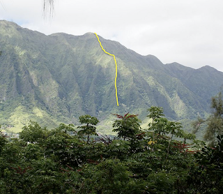
| Photo by Pete Clines |
One more PHOTO. It was taken from the Aiea summit recently when August, Laredo and I did the Halawa/Aiea Loop. (MUCH better weather that day.) This photo shows my route, though the bottom portion is not visible from this angle. Red for the way up, yellow for summit section.
-Pete


What a kick-in-the-pants climb! Thanks for posting this! For an account of the crew that met Pete at the summit check out this link - http://hawaiianforest.com/ahuimanu-uka-ascent-halawa-aiea-crossover
ReplyDeleteepic! clines is the man!
ReplyDelete