Pohakea Pass to Pu'u Kaua -- Lad Spinner
Today I went hiking in the Waianae range with four other folks, including my buddy Cleve Rich. Also hiking with us were Kawika Bew, Ming Ching, and Ming's friend Jean. We met at 8 at the Kunia Golf Course, then set off on the dirt roads thru the pineapple fields directly across Kunia Road from the golf course driveway.
We encountered pine field workers but they did not hassle us and we continued toward the mountain, following new/old jeep roads at times and wading through California grass at others.
Eventually we reached a spur ridge that climbed up toward the crest just to the right of Pohakea Pass. At the 1800 foot level (just got a new Casio Pathfinder altimeter watch), we hit the Honouliuli contour trail (HCT). Kawika and Cleve were ahead at this point and they missed the left turn they were supposed to make at the HCT. Instead, they kept climbing the spur ridge and, after some very steep climbing near the top, eventually reached the Waianae summit at 11 a.m. at a point between Kaua and Pohakea Pass.
Meanwhile, Ming, Jean, and I headed left along the HCT and eventually headed right and up toward the summit on an old jeep road that climbed up to Pohakea Pass. All this time, we thought Cleve and Kawika were ahead of us and when we reached the Pass at 11, we were surprised that there was no sign of them. Plus, as we hiked along, we noticed that spider webs across the trail were undisturbed, seeming to indicate that Cleve and Kawika hadn't come this same way.
Since it was still an hour before noon (and lunch), I decided to follow some old ribbons I saw that headed up the summit ridge in the direction of Kaua. About 60 meters up the ridge which was covered by ironwoods, I encountered a collapsed shed or hut, probably used by the military as and outpost years ago. Someone told me Pohakea Pass was the loneliest outpost on Oahu and that guards stationed there were known to freak out during midnight sentry duty. Yow!
Not far past the collapsed hut, I met up with a sheer vertical rockface that look much like monster teeth. Knowing I couldn't climb this face, I looked for an alternative and found a little contour trail on the right, probably made by goats. I contoured for maybe 60-70 meters and then found a steep hillside that I could go up with the aid of trees. Ming and Jean were behind me, and when Jean got nervous about going up the slope, they turned around and headed back down to the Pass.
So I climbed on alone, thinking that I'd make a go for Kaua. I yelled this fact down to Ming and Jean and I assume they heard me. So up I climbed, eventually gaining the summit ridge above the vertical rockface. The summit segment wasn't so bad at first, but then I reached some gnarly parts where I had to climb gingerly up and around rockfaces, semi-crawling in places.
 |
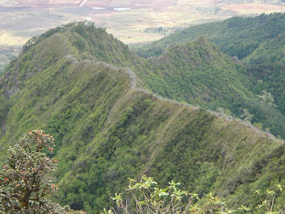
| Photo by Waianae Steve.
Pohakea Pass is at the top right of the photo, which was taken near the summit of Pu'u Kaua. |
Getting to them was no picnic, and I had to be very careful so that I didn't go plunging off the crest. Kawika descended two dicey rockfaces to meet me and once he did, he reversed directions and headed back in the direction of Kaua. He also directed me up the best line for both rockfaces. After these, the summit wasn't so bad.
They had already eaten lunch but both were willing to wait till I had stopped and eaten mine (Vienna Sausage) before heading to Kaua. The views were super clear today and with overcast skies and a nice breeze, we hiked in relative comfort.
The section over to Kaua was super, view-wise and we decided to head down tree snail ridge instead of going all the way to Kaua and heading down that trail.
About ten minutes down tree snail ridge, we encountered a brand new fence that contours across the steep mountainside at around the 2500-2600 foot level. I'm not sure who is building the fence or why, but getting it constructed is a bust-gut feat involving hauling gear and materials up to the fenceline. Impressive.
We got offtrack on the way down but after 15 minutes of searching we found the trail again and made good time heading down.
When we hit the 1800 foot level and the HCT, we decided to head right instead of left toward the Kaua trailhead. We reckoned that we'd pick up the route we had used in the a.m. pretty quick-like, but that was a bad miscalculation, and we ended up crashing and thrashing around in thick vegetation and ducking and crawling under Christmas berry tangles. No joy.
With some persistence and occasional grunts uttered to no one in particular, we eventually found our way back to the pineapple field roads that led us back to the golf course. Kawika, Cleve, and I arrived there at 3:45 and were surprised to see Ming's car still there. Where were Ming and Jean?
I waited around for a half hour and then took off for home. When I got there, I found a message on my answering machine from Ming, who reported that he and Jean had gotten back to the golf course at 5:15.
They gone offtrack but eventually found their way.
This was a good hike and I'll sleep well tonight for sure.
Aloha,
** Lad **


Comments
Post a Comment