Hawaiian Trail and Mountain Club Hike
Hiker leader: Turner
Hike date: August 2002
The map above shows the point-to-point distance of this hike as 3.14 miles (isn't that pi?) Of course, the hike was not as-the-mynah bird flies; therefore, the entire distance was probably closer to 9 or 10 miles.
Originally this hike had an advertised starting point in Moanalua Valley and an unnamed ending point but only a handful of club members expressed an interest in taking part. Instead of starting at Moanalua, the starting point was the upper point of Aiea Loop Trail on Aiea Ridge. For the hike, the group met and staged their cars at the end of Komo Mai Drive, which is the Manana trailhead. Then there was a car pool to Aiea Heights to the Aiea Loop Trail upper starting point. A few minutes past eight, the group set off up the Aiea Loop Trail, passing the traditional down-trail to Kalauao and a couple minutes later departing the Loop Trail to descend a contour trail (see rendering on a good map by Waianae Steve) into Valley # 1: Kalauao. Everyone moved along at a steady, relaxed pace and by 8:45 the gradual descent was completed and everyone was hiking along Kalauao Stream for ten minutes to arrive at place called the Sun Rocks. Short break there.
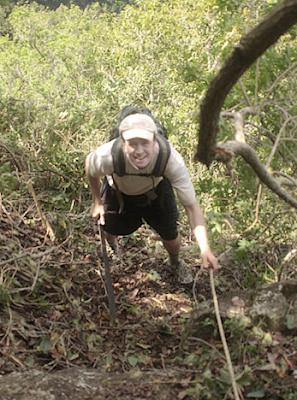
Next commenced the 20-minute clamber of Sun Rocks Ridge which is ranked as the toughest climb of the hike with the ascent being a hard heart pumper. Once completed is the satisfaction completing the first of the day's three big climbs. Longer rest at the top of the climb.
After the rest, the group continued mauka up Onikiniki Ridge which was well cleared on that day but may be a quagmire of uluhe circa 2011 and beyond (see an uluhe pic circa 2008). After fifteen minutes of hiking, the group arrived at the junction of Onikiniki Ridge and Little Waimalu Ridge. Resting on a tree branch at the junction was a collapsible cooler filled with bottles of Gatorade on ice! The drinks were courtesy of Dr. Gene Robinson, who lugged the refreshments up the day before for the group today. Fueled with Gatorade, the group continued along Little Waimalu Ridge, going up and over several pu'us along the away. In about twenty minutes was the arrival at a ribboned junction where Little Waimalu is left behind and the descent of a spur into Valley #2: Big Waimalu begins. The descent was made quicker and easierthanks to the recent clearing efforts of several members of the club.The descent into Big Waimalu took about half an hour (see pic below). During the descent, in view across the valley was the trail to be climbed to Waiau Ridge etched into the slope of a facing spur ridge (note: trail may not be visible or existent circa 2011). Meanwhile, the spur trail being descended delivered the group to the base of Waimalu Middle Ridge, the venue of one of the early HTMC super hikes. Today, no one would climb the Middle Ridge; instead, the objective was to cross Waimalu Stream (bone dry) and then head up the spur trail spied a few minutes prior. Ribbons placed just two weeks prior to mark the ascent route were nowhere to be found today. Fortunately, Turner had good recall of the route and the climb to Waiau Ridge commenced.
The climb of the spur trail was a 30-minute grinder which is ranked as the second toughest of the day's trio of big ascents. Brisk and steady trade winds flowing down the valley were welcome and were helpful in keeping hikers cool while making the climb less taxing. By 11:40, 3.5 hours after setting out, the group had reached the Waiau Trail at a heavily ribboned junction just makai of the Waiau's Big Dip (see map below). Glad to have two big ups in the bag, the group hiked makai on Waiau and on the first significant hilltop everyone settled down for lunch.
At 12:30, the group continued makai on Waiau. About half an hour of rollercoaster hiking from the lunch spot, it was 1:00 p.m., and the group arrived at the candy cane tree (a tree with a long pink ribbon wrapped around it) that marked the junction with the Halapepe Nui Trail (pictured below). At that point, the Waiau trail was departed and the group headed off on Halapepe Nui, the next designated stop being the top of the switchbacks down into Waimano Valley.
 |
Start of the Halapepe Nui Trail from Waiu
Pic by Bart Mathias |
The traverse of Halapepe Nui took a bit over half an hour. A bit past 1:30, having completed the medium ups and downs of the mildly overgrown Halapepe Nui trail, the group arrived at a Na Ala Hele sign that sits atop a switchback trail to be descended into Waimano Valley. The group rested on a log in a breezy clearing surrounded by towering eucalyptus.After the rest, everyone again rose and this time headed down the Na Ala Heleswitchbacks, which is a wonderfully graded and maintained trail that few people hike or even know about. A shame.In fifteen minutes, completed was the descent of the switchbacks and the arrival in Valley # 3: Little Waimano, at a junction with the Waimano Trail. Heading mauka, hikers crossed Little Waimano Stream (dry) and almost immediately arrived at the entrance of a tunnel that everyone hiked through to get to its far end. Flashlights are suggested for the hunch-over scramble through the dark tunnel.At the 200-meter tunnel's far end, the group followed ribbons to descend steeply but quickly to Valley # 4: Big Waimano, in a tangle of hau on a bank of Big Waimano Stream. Just like the other streams encountered earlier, this one is bone dry, which is a marked contrast to two previous visits to this crossing by Turner when he had to balance on hau branches to avoid wading through a chest-deep pool. With zero water in the stream today, the group made good time on this leg, whichrequires hiking in the streambed for a while when a trail isn't available on the bank. In all, there were ten to fifteen minutes saved because of the lack of water in the stream.The final crossing of Waimano Stream was at the confluence of two streams. Just makai of the crossing is a large clearing called the Mango Tree Campsite. The group tooks its final rest stop of the day at the campsite, which had a large fire pit that looked recently used.Rested, everyone set off for the final climb of the day, the notorious Cardiac Hill of Waimano Pool. This climb wasn't as daunting as advertised, and in fact, during the ascent (which hikers rated as the easiest of today's Big 3), everyone climbed with good speed and strength, passing three day hikers, who say their visit to the pools revealed them as being low, stagnant, and plain uninviting. When the group reached the top of Cardiac Hill and the junction with the Manana trail, it was 2:45.From there, the hike was completed with a short tramp down the Manana Trail. Earlier, Turner predicted a finish time of 3:00 p.m. which was close to the actual ending time of 3:07. Based on how early this hike was finished, it would have been feasible to keep hiking to Waiawa along the Manana Ditch Trail route tofinish at Waipio Costco. A goal for future hikers?Hike on and Go HTMC!


Comments
Post a Comment