In Hawaiian, Loa means long. Hauula Loa, then, means Long Hauula. Some call this the longest ridge on Oahu. While that may not be true, this hike is indeed a long one which can be made even longer since this ridge is rarely hiked and thus very overgrown. The HTMC hiked this trail as a club outing on Aug. 24, 2002. This writer knows of no others who have hiked this entire route since.
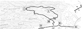
The hike starts along Kam Hwy and Hauula Homestead Rd. (google map) Leg 1 is from cars to top of Hau'ula Uka Loop and is probably the hardest leg, aerobically. It will take about an hour. Plan on some heavy heart-pumping on these initial series of climbs. The map shown here (which is from Stuart Ball's book) is of the Hauula Loop.
 |
| From Hikers Guide to Oahu, Stuart Ball |
At Map Point H, head left at the junction to take the loop in a clockwise manner. The loop trail will top out on a ridge before descending to Map point I. At that ridge location, head up the ridge on a trail instead of descending to Map Point I. At this point, you will have left the Hauula Loop and are on the Hauula Uka Trail. At the top of Hauula Uka is a junction with the start of Hauula Loa Ridge
Leg 2 is to Three Ribbons Pu'u. This took 1 hour in 2002 but may take much longer nowadays due to lack of hiker traffic thus heavy overgrowth or even a lack of a swath. Even with a trail to work with, plan on a slower pace due to thicker vegetation and less of a trail to work with. The three ribbons, by the way, mark the end of the (occasionally-used) extended portion of the Hauula Uka hike done by the Trail and Mountain Club. That pu'u may be hard to distinguish circa 2010 and those ribbons may in fact be long gone, so hikers take note. Also note that there are some huge drops on the right down into upper Kaipapau Gulch. The ridge never gets perilously narrow but do note the drops are some of the most significant this hiker has ever encountered. Leg 3 Three Ribbons Pu'u to Castle Trail junction took 2 hours in 2002. On this leg, you will be in a very remote area of Oahu. Plan on some tough going due to heavy vegetation. An established swath would be very helpful but do not anticipate that. Take note of views on the left into upper Maakua Gulch. Circa 2010, the junction with the Castle Trail should be fairly discernible due to recent use of the Castle Trail by HTMC. From that junction, recommended is a short trek down Castle for 10 minutes and lunch at an overlook of a waterfall. It is a nice spot (see pic below)
Leg 4 From the waterfall overlook, continue down Castle to the junction of Castle and Papali Uka. At this point, exit options are [1] via Castle (mostly downhill thus easier and faster) or [2] via Papali Uka (harder rollercoaster trail exit). Though easier, the Castle Trail exit will involve a long road walk back to your car or the need for a vehicle staging, shuttle at or near Punaluu Valley Road (google map). Also note that hiking on the Castle Trail is conditional, with permission required from the landowners, the Kamehameha Schools.

Comments
Post a Comment