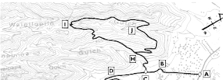
Konahuanui via Lulumahu

Konahuanui, the highest peak in the Koolau Range, is usually reached via the Tantalus Trail system at a trailhead on Tantalus Drive (see google maps ). In 2001, another route to Konahuanui was employed. Herein is a description of that ascent and subsequent return which in total accounted for 8 to 10 miles. The starting point is the hunters' check-in where Nuuanu Pali Drive rejoins Pali Hwy. ( google maps ). We started along the muddy trail to Lulumahu Falls and after two stream crossings (very near Lulumahu Falls) we stayed on the left bank to begin climbing a roughly cut trail that went up the left ridge of Lulumahu. There was one section where the ridge narrowed to a razor edge. There was one steep section with a strap (dunno where it came from) for climbing assistance. Keep in mind that this was in 2001. That strap likely is not there or very frail if it is. Take note.After that, the ridge is fairly broad with no overly dangerous parts. Like the regular Konahuanu...


