Posts

Upper Sacred Falls

Image
Photo by Nathan Yuen In early December 2010, a group of five which included extreme hikers Pete Clines, August Smith, and Nathan Yuen, hiked up the Papali Ridge extended trail, down the Castle Trail, and then down Kaluanui Stream to down-climb several waterfalls. Nathan Yuen filed this report on his blog.

Hihimanu by Peter Artley

Image
Photo by volcantrek 8/waialeale.org Hike date : May 2006 I figured it was going to be relatively easy to summit the shortest mountain in Hanalei Valley. The elevation is only about 2400 feet and it took less than an hour to hike the first two miles, even if it was a bit steep at times. I didn't realize how totally crazy the trail to the summit is though. The first indication that only the extremely brave, or insane, should attempt this "hike" was when i came upon a rope descending through dense brush on a knife-edge ridge. Without a second thought i snatched the rope off of the ground and began the precarious descent, facing forward (i.e. down-hill.) The rope was obviously weather worn, but despite the signs that it had seen several rainy seasons it seemed sturdy enough to hold my weight, and did. Even when i tripped and caught myself while walking that first section of densely covered "trail" i didn't have the slightest intention of turning back.

Mariner's Ridge Windward -- Pat Rorie

Image
Hike date : 2 April 2003 Definitely one of the more memorable pau hana hikes I've done in recent years.For subscribers of OHE-L who aren't aware, during the past few years some of us on this list have been searching for do-able windward Ko'olau ridges as counterparts to prominent leeward Ko'olau trails. A few of these trans-Ko'olau routes have existed for decades (i.e. Schofield-Waikane, Kawailoa-Laie, and Haiku Stairs Moanalua Valley middle ridge). The late Silver Piliwale pioneered Piliwale Ridge (aka Windward Konahuanui, the narly ridge visible as one drives along the Pali Hwy hairpin turn), which Jason Sunada, Pete Clines and I have climbed recently. Silver also blazed a trail up Kaupo Cliffs (part of the Kaupo Cliffs-Kamiloiki Ridge traverse). The Bear Claws-Pu'u o Kona-Kuliouou Ridge is another example of a trans-Ko'olau route; author unknown. A group of us established a trail on a ridge in Waiahole Valley dubbed Kipapa Windward because it to

Oahu's Gnarliest Trails

Image
Chris Walker Here is Chris Walker's take on the most dangerous and daunting hikes on the island of Oahu. His top five include the KST, Pu'u Manamana, Pu'u Kalena, Pu'u Ka'aumakua, and Olomana.

Lanihuli Windward

Image
Submitted here is a photo of the probable route of Lanihuli Windward. As of 2010, this route has not been traversed in a number of years. Hawaiian Trail and Mountain Club veteran John Hall has done this with Chuck Godek. According to Hall, Godek was the lead climber, who would ascend, tie off a rope, then beckon Hall to follow. Using this grind-it-out-to-the-top method, they eventually acquired the summit. Year: unknown but probably in the 1950s or 60s. The access would be from the Likeke Trail, mauka of the Koolau Golf Course.

What's Hawaii's Toughest Hike?

Image
National Geographic lists the Muliwai Trail as Hawaii's toughest.  What's your choice for Hawaii's toughest hike?

Pohakea Pass to Pu'u Kaua -- Lad Spinner

Image
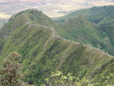
Hike date: January 2000 Today I went hiking in the Waianae range with four other folks, including my buddy Cleve Rich. Also hiking with us were Kawika Bew, Ming Ching, and Ming's friend Jean. We met at 8 at the Kunia Golf Course, then set off on the dirt roads thru the pineapple fields directly across Kunia Road from the golf course driveway. We encountered pine field workers but they did not hassle us and we continued toward the mountain, following new/old jeep roads at times and wading through California grass at others. Eventually we reached a spur ridge that climbed up toward the crest just to the right of Pohakea Pass. At the 1800 foot level (just got a new Casio Pathfinder altimeter watch), we hit the Honouliuli contour trail (HCT). Kawika and Cleve were ahead at this point and they missed the left turn they were supposed to make at the HCT. Instead, they kept climbing the spur ridge and, after some very steep climbing near the top, eventually reached the Waianae