Posts

Lanihuli East -- August Smith

Image
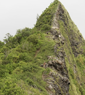
Lanihuli and reaching it from the Pali Lookout has captivated my imagination and only that for a long time. It was off limits and as far as I was concerned way too dangerous to attempt. I had heard the stories of Kalanikupule and his wife escaping Kamehameha's forces using this route, the 1915 article in the Mid-Pacific Magazine, Lost on Lanihuli By R.H. Lambert , the scouting trip of Al Miller and more recently stories of a "father and son team" that was working on this very route around 2000 - 2001 and they made it! And then Pete Clines did it in April of 2010 ! There are plenty of accounts of people who have not made it and even for those who have, it usually takes multiple attempts. Before continuing on I would like too say thank you to everyone (especially Pete and Stanley) who has put in work and put up ropes, cables etc. to make this a more "manageable route." Without your help this would have been a lot more time consuming and difficult! Afte

Descent into Milolii

Image
In 2008, hike guide and Kauai extreme hiker, Eric Rohlffs, descended into Milolii Valley along the steep-cliffed Na Pali Coast on Kauai. The pic above is the mouth of Milolii taken from a vantage point on the ocean. Rohlffs descended the ridge on the righthand side of the valley mouth. He posted the pics below. Others have likely descended this route, including volcantrek8 , who issued the following warning: The bushwhack descent into Milolii is hazardous with fatal drops aplenty. Noted Kauai photographer, author and Kauai Natural History Expert David Boynton was killed on the decent to Milolii in 2007. The descent is not recommended and these photos are only intended to show the variety of wilderness experiences and magnificent views off the established routes. There is no trail. Goats get weak kneed. Much KKKK (crumbly cliffs of Kauai clay). Bring your own handholds.

Mauna o Ahi Windward (MOAW)

Image
Scott Villiger and Dayle Turner completed the ascent on August 13, 2003. They described the climb as "easier than anticipated." Initially, they showed up at the end of Manoa Road at 9 to do some exploratory hiking in Manoa. However the others were no-shows so they decided to go elsewhere to hike. Turner bounced several hike venue options off of Villiger and the one they decided on was an exploratory of the ridge they had spotted a week ago after they had climbed Hahaione's middle ridge. The spotted ridge Turner christened Mauna o Ahi Windward (MOAW) because it crests out very near the topping out point of the ridge of this name. So from Manoa, they drove over to the windward side, leaving Villigers's car at the HTMC clubhouse. They then jumped in Turner's vehicle and drove over to the Waimanalo District Park, where they set off hiking along the 'Nalo backroads, destination the starting point of Bear Claw Ridge. Ten minutes later, they got to the Bear Cla

Search for Lake Waianapanapa -- Pat Rorie

Image
Lake Waianapanapa -- Photo by B. Gagne With a layover day at Paliku (lit. "vertical cliff") came a leisurely morning. Although Paliku was still engulfed in shadow, the early morning sunshine lit up the massive ridge containing Haleakala Peak, the lava fields of the crater floor, Pu'u Maile, and Oilipu'u beautifully. At 9 a.m. Arnold, Chris and myself set out to explore the territory above Paliku along Kalapawili Ridge (part of the crater rim) in hopes of locating (and swimming in!) Lake Waianapanapa. We were blessed with another perfect day weatherwise (a light breeze, clear blue skies with the exception of a few cirrus clouds, an abundance of sunshine). A sign stating "unmaintained trail" behind the campground denoted the Lau'ulu trailhead and we headed north on the footpath. I brought ribbon to mark potentially confusing junctions for Inger and Laura who would be hiking Lau'ulu later that morning. We gained elevation gradually and passed t

Kalihi Saddle -- Pete Clines

Image
  Last summer I made several trips to upper Kalihi Valley to explore the Koolau saddle between Lanihuli (to the east) and the peak next to the Bowman Trail terminus (to the west.) I found a ridgeline that is narrow and crumbly, making for an exciting walk. Anyone who has ever looked up at this area over the Wilson Tunnels has noticed a number of sharp ups and downs which add difficulty to this walk. In order to reference them, I have given silly names to these menacing pinnacles: Witch’s Hat, Shark Fin, The Bunny Ears, Doorstop, Pimple, and Can Opener. (From west to east) This shot was taken from a scout trip last year from a spot partway down the west ridgeline of Lanihuli. The red and blue dots mark the two routes I put together to climb or descend the saddle. The orange “flags” mark the extent of how far I have gone in either direction. The left flag is the “Witch’s Hat” and the right is the “Doorstop.” Last Sunday, we went up the blue (look closely) and down the re

Ohulehule Southeast Ridge

    In April 2011, Kaleo Lancaster and friends completed a successful ascent of Mount Ohulehule's southeast ridge, the same ridge that two Danish female hikers were stranded on years ago. OSE has not been hiked much if at all in recent years. But now that Lancaster and crew have done it, perhaps more intrepid ones will follow ala Piliwale Ridge

Descent of Mauna Loa via Southwest Rift -- By John B. Hall

Image
Not many people have done the traverse of Mauna Loa and descended the Southwest Rift. Before I did it for the first time, I talked to all the old-timers I could find, and couldn't locate anyone who had done it or knew of anyone who had, with the possible exception of one of the geologists at the Volcano laboratory. It is not easy to explain the challenge of this trip to the average layman, or even to most experienced hikers. Craig Chisholm, in his book " Hawaiian Hiking Trails " characterizes the climb of Mauna Loa from the Strip Road to the summit cabin as "one of the hardest hikes in the Hawaiian Islands". This is entirely justified, yet the end of the trail at the summit cabin represents the final departure from civilization and the doorway to the truly untouched wilderness for those who attempt the still more challenging trek down the Southwest Rift. As one leaves the summit cabin and travels around the rim of the caldera to South Pit,