Posts

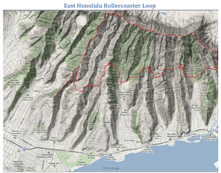
It's Been Awhile -- Kahuali to Kalihi Saddle

Image
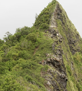
Not sure how many years it's been. Maybe 30 or 40. But the section of the Koolau crest from Kahuauli (Bowman trail terminus) to the saddle atop Kalihi Valley (above Wilson Tunnel) has been done by Dave Concepcion and friends. He reports: There are three saddles on the Ko'olau mountain range on the island of O`ahu. All three have trans-Ko'olau tunnels running underneath that are part of highways that link the windward side of the island to Honolulu and Waikiki. These are the Moanalua (H-3), Kalihi (Likelike), and Nu'uanu (Pali) Saddles. Numerous hikers have documented their hikes on the Moanalua and Nu'uanu Saddles while Kalihi remained virtually untouched. Hawaii hiking legend Dick Davis called the section between Pu'u Kahuauli and the Kalihi Saddle as no-man's land. Pete Caldwell and Don Fox ascended to the saddle via a steep trail that was situated above the Likelike Tunnels on July 14, 1997. Pete Clines and company did a loop from the h

Lanihuli Windward -- Pete Clines

Image
Some time away from the mountains had me aching for adventure. Thought I would check out this one to scrape the rust off. Turns out it had a little bit of everything: an obscure start, brittle rock, crawler’s ledges, and some ridiculously steep slopes. It was also overgrown; with the upper half being a complete bushwhack. And starting the actual climb from ~600’, there was about 2100’ of elevation gain in a VERY short distance. All told, it was a grueling ascent And most refreshing. 8:15 I left the car parked at the Golf Course/Church. Not sure what it is used for these days. Passed by the waterfall, and eventually reached the point where I would start the ascent. And I am being vague on purpose. This route is very dangerous. Although MUCH less taxing now that is has been cleared, there are a couple critical spots that suffer greatly with each passing hiker. And these spots were horrible BEFORE I further damaged them. Fair warning. The route can be imagined

East Oahu Super Loop -- Duc Ong

Image
Duc Ong completed a truly super hike, starting and ending at the top of Maunalani Heights at the head of the Lanipo Trail (aka Maaumae Ridge Trail). Here's his report: First, I would like to thank all of the people who have helped me clear and mark these trails and to all those who came before and provided the inspiration for this project. Not wanting to implicate anyone, I won’t name any names. The route was developed as an expansion to the East Honolulu Rollercoaster, which started from Wai‘alae Nui Valley and ended in Haha‘ione Valley. I wanted to make this a closed loop, so as to avoid the need for car shuttling. In the misty wet morning of the day after the summer solstice at 4:30 AM, at the Lanipo trailhead, I embarked on what is the longest day hike I’ve ever done. By 5 AM, I was beginning the descent down “Ironwood” trail into Wai‘alae Nui Valley. The trail itself hits a pseudo-bottom, where one might think that one has arrived at the valley floor. However

Poamoho/KST/Castle/Papali Uka -- Keith Palmer

A Koolau Summit Trail hiker from the mainland told me about a water source he found in the Peahinaia section of the trail, and referenced in one of Stuart Ball's books. It is on the windward side of the trail at Peahinaia at a gap. He was able to make a mud dike, stick a straw through it, and slowly fill a water bottle. For people who might not get to the excellent water source at Poamoho junction or those studying the plants in the fence interior and staying thereabouts, decided to pack up and see if I could find the meager source. Thursday June 27, 2002 6:05 AM Walk out the door of house with light backpack. Worked the night before until 3:00 AM and had packed up just before leaving. 6:20 AM Arrive at Hookele and Farrington Highway bus stop. 6:37 Bus #40 "Honolulu" arrives. Pay $1.50, the new higher bus fare, and get a transfer. Thinned down internal frame backpack draws no comment from the driver, and I slide it under my bus seat. 7:28 Get off bus

Lanihuli East -- August Smith

Image
Lanihuli and reaching it from the Pali Lookout has captivated my imagination and only that for a long time. It was off limits and as far as I was concerned way too dangerous to attempt. I had heard the stories of Kalanikupule and his wife escaping Kamehameha's forces using this route, the 1915 article in the Mid-Pacific Magazine, Lost on Lanihuli By R.H. Lambert , the scouting trip of Al Miller and more recently stories of a "father and son team" that was working on this very route around 2000 - 2001 and they made it! And then Pete Clines did it in April of 2010 ! There are plenty of accounts of people who have not made it and even for those who have, it usually takes multiple attempts. Before continuing on I would like too say thank you to everyone (especially Pete and Stanley) who has put in work and put up ropes, cables etc. to make this a more "manageable route." Without your help this would have been a lot more time consuming and difficult! Afte

Descent into Milolii

Image
In 2008, hike guide and Kauai extreme hiker, Eric Rohlffs, descended into Milolii Valley along the steep-cliffed Na Pali Coast on Kauai. The pic above is the mouth of Milolii taken from a vantage point on the ocean. Rohlffs descended the ridge on the righthand side of the valley mouth. He posted the pics below. Others have likely descended this route, including volcantrek8 , who issued the following warning: The bushwhack descent into Milolii is hazardous with fatal drops aplenty. Noted Kauai photographer, author and Kauai Natural History Expert David Boynton was killed on the decent to Milolii in 2007. The descent is not recommended and these photos are only intended to show the variety of wilderness experiences and magnificent views off the established routes. There is no trail. Goats get weak kneed. Much KKKK (crumbly cliffs of Kauai clay). Bring your own handholds.

Mauna o Ahi Windward (MOAW)

Image
Scott Villiger and Dayle Turner completed the ascent on August 13, 2003. They described the climb as "easier than anticipated." Initially, they showed up at the end of Manoa Road at 9 to do some exploratory hiking in Manoa. However the others were no-shows so they decided to go elsewhere to hike. Turner bounced several hike venue options off of Villiger and the one they decided on was an exploratory of the ridge they had spotted a week ago after they had climbed Hahaione's middle ridge. The spotted ridge Turner christened Mauna o Ahi Windward (MOAW) because it crests out very near the topping out point of the ridge of this name. So from Manoa, they drove over to the windward side, leaving Villigers's car at the HTMC clubhouse. They then jumped in Turner's vehicle and drove over to the Waimanalo District Park, where they set off hiking along the 'Nalo backroads, destination the starting point of Bear Claw Ridge. Ten minutes later, they got to the Bear Cla