Finally got to do the crossover between Kawiwi and Kamaileunu! I have been interested in this route since hearing that Al Miller did it years (and years) ago. I was supposed to take some of the gang up there back in January, but I got sick and spent that weekend in bed. Then the weather was just uncooperative all the recent Sundays. But this past weekend we had the trades back and the forecast was for less rain, so we (Kevin, Duc, August, and I) went for it. Below is the route starting from the usual trailhead in Waianae Valley. The blue arrow marks the notch which is where it gets particularly exciting.

After leaving my car near the Kamaileunu trailhead, we rode in Duc’s car to our starting point, and set off up the paved road at 8:30ish. The road was wet and slick - not a good sign as we would prefer dry conditions for a safe climb up and across. From the curve in the road we ducked into the forest on the path to the base of Kawiwi. Most of my ribbons from last year were gone, but we had no trouble finding our way. The heavy rains lately had caused a lot of growth. We waded through torso-high grasses on the approach… and even the rocky scrambles at the base of the climb were covered in “green.” As we gained elevation, the greenness subsided, and we tackled the rocky sections carefully as they were moist and our shoes were not getting much friction. In fact, after a few minor slips I began to
rely more on pulling with my arms than trusting my legs.

Above, Kevin casually offers August “a hand” on one of the rocks. Below left, we came across a familiar trail-marker. Last winter, I had tied a pink ribbon through the eye sockets of this goat skull as a surprise for the others in our group. Totally faded, it still gave the skull a decidedly feminine look.

Above right, Duc points out the best way up a large, smooth boulder. It looks much easier in the photo, but the lack of dry handholds made this a fun “bouldering” challenge. From there we continued upwards, with Kevin occasionally asking if we were there yet. As the only one with an altimeter, I kept reassuring him that we were getting closer.
We were fortunate that the weather stayed cool and overcast, but with only minimal sprinkles. When it did spit on us, I secretly wondered if we would have to skip the crossover if it got too slick. But
at 11:10 I found myself on the broad, open summit and was more optimistic. The others joined me shortly after, and we enjoyed a leisurely lunch break with panoramic views. Looking mauka, we could see “No Name Peak” and the ridge beyond. Duc has been that way before…August and I have done that section twice…and the weather was more menacing in that direction than makai. So at noon we packed up and prepared to keep with our original plan.
Immediately after leaving the summit of Kawiwi, there is a sharp drop on the makai side of the ridge. Having scouted this way last winter, my cable was still in place as an aid to get down. Not wanting to trust it 100%, I set up a second rope. Since there are no dependable trees, I looped it around the large boulder – similar to my cable - but leaving both free ends hanging down. This meant descending while gripping both ends, but since it was not tied to anything, we were able to retract the rope from below once we were all down. Group consensus was to lower the packs on a separte rope to ease the process. (below left) Duc was last man down. (below right)

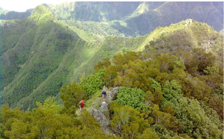
Once everyone was down and the ropes were put away, I led the guys down the saddle of the ridge. The first half has its rocky descents, but also a bunch of bushwhacking through haole koa andother progress-slowing branches. After the low point – was it 2600’? – we began to climb a crazy pile of boulders that I liken to “a giant’s building blocks” in a previous report. At one point, there is a large square block in the way. You can either do a jumping pull-up on top of the rock, and then a jump off the other side (as Duc and I did) or carefully tunnel under the block (as did August and Kevin) on the narrowest of ledges. Immediately after that, we reached the massive rock outcropping that marks the mauka side of the notch. This was as far as I had gone during my previous scout trip. The views from here are truly awesome and the drop into the notch is imposing. Below is a shot of August and Duc approaching the notch. Kawiwi’s summit is at the center of the photo.

Once gathered at the notch, I pointed out the old cable dropping into it that I found last year. Since this is likely Al Miller’s…and thus at least a decade old…I opted to install our own safety line. The drop here is long, smooth and scary. A broken cable/rope would be the end of you. As with the cable, I decided to loop the rope around the strongest object – a boulder partway down the notch. Since we wanted to be able to retrieve the rope as before, I cut a length of August’s strong rope and looped it around the boulder, knotting it off at a pinch point in the back. I then snaked another rope through this “loop anchor,” again, with both free ends hanging down so we could simply pull it to us when finished.
I went down first to get the ropes straightened out and check for footing. As luck would have it, the two ends of the 50’ rope were just long enough to get me to a usable ledge. Just below that was a relatively level spot. This makes the main drop about 25’. Add in the drop to the anchor point, and the final drop below the rope to the level spot, and total height is roughly 40’. However, the drop just slightly to either side – if one were to fall – was an additional several hundred feet. From the level spot, Kevin and I were able to snag the packs, including August’s bag-o-bricks, as the guys lowered them. Because of their angle, they would toss the packs outwards until the rope went taught and then they could lower them. Seeing these heavy packs momentarily free-falling on us was nerve-wracking as we had no where to go if the rope snapped or they misjudged the amount of slack.
Below is the view looking back up. Rock is overhanging here, so we descended just to the left.

Below is a photo of the guys celebrating. All the packs have safely made it down to us.
Kevin took a photo of me guiding Duc down the wall as August repacks a rope. Behind me is a horrific drop. In the background is “No Name Peak.” The weather was steadily improving by now.
Below, Duc begins, and then completes, the descent of the mauka side.
From the notch, we climb back out on the makai side. A series of steep, natural switchbacks keeps it rather simple, and we make it up the wall with less difficulty than anticipated.
The ridge begins to level off, and we know we are just below the Kamaileunu Trail terminus.
At 2:30 pm, I notice “three pinks” and recognize the large boulders marking the end of the Club hike. The challenging crossover took a full 2.5hrs but never had a dull moment. A fantastic stretch.
At 3:30 pm we finished our second lunch break and packed up to leave. At 3200’ and under high clouds, the conditions were cool and comfortable, and we were all smiles. But as we got lower and closer to the coast, weather got progressively sunnier and hotter, resulting in a different expression, as seen below left. Are we there yet?

As we moved along we couldn’t help notice how green and overgrown Kamaileunu was. The high grass made it tough to avoid hidden rocks, so a slower pace was warranted. The number of evil plants up there was also shocking and several varieties would leave “spikes” in your socks, skin, or anything else they touched. Worse still were these unusual “trail mines” as seen above right. None of us had remembered seeing these before, but Nate has since identified them as Leonotis nepetifolia or “Lion’s Ear.” They were all over the lower portions of the trail, with a patch covering the trailhead that grew about head high! They would sharply poke you with even the lightest contact. Very annoying.
Despite the painful entry onto the paved road and back into civilization we were thrilled with the day’s outing. We walked through a neighborhood replete with barking dogs and were back at my car at 6:10pm. We had just enough daylight to drive back into the valley and retrieve Duc’s car before darkness (and additional theft risk) set in. A traditional post-Waianae-hike trip to Jamba Juice for coldsugar pleasantly concluded the day.


Comments
Post a Comment