Posts

Showing posts with the label oahu-koolau

Mamama -- Manana, Waimano, Manana

Image
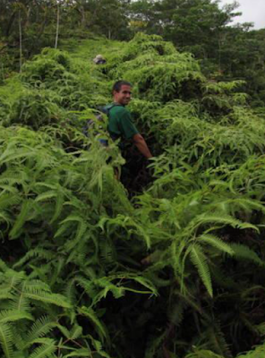
August Smith (front) and Nate Yuen on the Manana trail Author :  Pete Clines Hike date : August 2010 ...when you summit via Manana, come down Waimano, but finish at Manana.  (The other version would be Wainano, btw.)  Sunday was SUPPOSED to clear up in the afternoon.  Never did.  At least not where we were during this marathon trek.  August Smith, Laredo Murray, Nate Yuen and I met up at the Manana trailhead and pushed off at 7am.  Overcast skies and socked-in summits kept the ascent cool and comfortable.  Expecting too sweat more, I carried 5 liters of refreshments but only drank 2.5 in the end.  Lively conversation carried us along the otherwise uneventful trail.  We also paused tooo check out several side trails that will require exploration in the future.  We stayed together, and by 10:45 or so we were all at the Manana summit.  A lunch break occurred, and we sat in the canopied area toooo talk story.  After a while Nate departed back down the Manana trail as he had a comm

Pali Notches to Piliwale -- Pete Clines

Image
Hike date : 23 January 2011. In January of 2003 I climbed up to Konahuanui from the Pali Lookout by way of the “Notches” ridge. My climbing buddy back then, Brian, was naïve enough to join me. Except for a tense moment when a handhold-rock busted loose on Brian while in a crucial spot over a death drop…. we had a fantastic time with lots of excitement and killer views on a cloud-free day. We exited via the seldom traveled (overgrown) Lulumahu Ridge and looped back to the Lookout.   This past Sunday – almost exactly eight years later – I got Laredo (Murray) and Duc (Ong) to join me for another round of adrenaline. This would be their first time on this ridge. We met at the Lookout and began for the Notches at 8:30 or so. Below is a map of the route, with the orange dash marking the hardest part. This picture was taken from the summit of Lanihuli East – the equally nasty ridge across the valley. We got to the ridgeline in no time, and were treated to a blast of wind. W

Olomana 3rd Peak (Ahiki) backside

Image
http://www.youtube.com/watch?v=6Feq7JBQa8c

Loop of Waiahole Middle (aka Old Kipapa Windward) to Waiahole Uka (Current Kipapa Windward?)

Image
Around the turn of the century (I love saying that) a group of hardcore HTMCers scouted a prominent windward ridge that divides Waiahole Valley into north and south. They named this ridge “Waiahole Middle” and/or “Kipapa Windward.” Aside from two notches roughly mid way up, their reports indicate a ridge that was otherwise gradual and seemingly “doable.” They managed to get past the lower notch, but stopped at the imposing second notch when common sense prevailed. They were later successful in scaling its neigbor to the north, which is now an advanced Club hike named “Waiahole Uka” (or occassionally “Kipapa Windward.”)  Having less common sense than Dayle and Patrick and crew, Chase and August and I decided to check out the “original” ridge – the one with the notches – to see if we would have better luck. A detour including pie and koi fish (don’t ask) meant that we would have safe parking in the valley, but also a late start. At 9:40am we began into the valley, first on the jeep road,

Koolau Summit Trail 8-day thru hike by Chase Norton--Chapter 4: The Trip, Day 8, Konahuanui to Makapuu

Image
Day 8 (04/01/12), Konahuanui to Makapuu, 15 hrs, 10 miles Total Pack Weight: 18.6125 lb. The standard trek. It's the cool down from the workout. Enjoy every moment and laugh the entire way. You have made it, but still take caution, now is not the time to injure yourself. If you do not have it in you to finish today there are many camp options. Mariners, Camp Awesome and Chaps to name a few. But you got this so push! Bail: A lot, don’t do it though Pitter patter against the tarp woke me around 6:30 am and I decided to try and wait for it to pass before getting out of bed. Shortly, the rain ceased and I began what would turn out to be the last day of my journey. Today I started with 3L of water to get me to Makapuu and what does idiot me do? Make 500ml of coffee to start the day! Really would have enjoyed that water later in the day. Mistake 3. At K1 there used to a pink ribbon blocking the descent of a side ridge. It is no longer there and in the fog of my morning mind and the excit

Kulepeamoa Windward (aka The Big Nasty) by Pete Clines

Image
I never thought I saw any windward ridges between Puu O Kona and Lanipo that looked climbable….but I WANTED there to be one. So to force the issue, Chenay, August, and I went on a scout trip to Waimanalo last weekend for some sight-seeing. Most of what we saw was utterly horrible, as evidenced below. Vertical ridges tightly packed together, with majorly rotten rock throughout. While hopefully observing each ridge, a group of church-goers stopped to talk with us. Upon learning why we were staring at the mountains, one of them mentioned that some “professionals” had tried unsuccessfully to climb some of those ridges in the past. Not sure what makes a “professional” but the challenge was definitely on. We agreed it would be another “dragon-slaying” adventure. (Back-story: dragons live in dangerous, remote areas like this and guard against intruders. Completing the adventure means slaying the dragon. Got it?) While almost all of these ridges were quickly dismissed as suicidal, one

Bowman Windward -- Pete Clines

Image
For years I have driven the Likelike Hwy and stared up at the jagged ridges on the windward side of the Wilson tunnel and wondered if they were climbable. Turns out (at least) one of them is. During a recent decent of “Bowman East” with August, Duc, and Laredo… I had time to study those windward ridges from above and later from more of a side angle. Coupled with observations made from Hoomaluhia below, I picked out a route that had potential. So on the last day of 2011 I set off with Chenay to check it out. We started from a neighborhood in Kaneohe around 9:30 – late start since the plan was only to “scout” it. With two major obstacles (H3 and Likelike) between us and the ridge, even the approach required some pre-planning. But a few looks at the topo maps and some common sense in regards to drainage meant we would avoid becoming roadkill. With obstacles 1 & 2 behind us, the task was to find the ridge I had in mind. Looking up, I was reminded of why it was important not