Posts

Ascent of Kamakou

Image
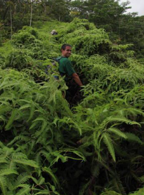
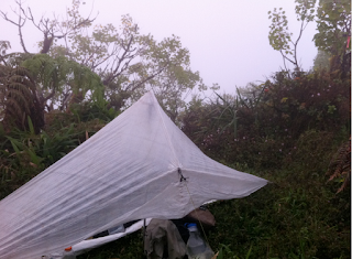
Ascent of Kamakou by Rob Woodall   9 Jan 2013 We (Laura Newman, Adam Helman, Duane Gilliland and I, Rob Woodall) take an early flight from Lihue via Honolulu to Molokai. John Mitchler, Don Nelsen and Bob Packard are already here: John meets us at the airport, Art picks up a rental car and we drive into town to buy food, water and cooking fuel. We have lunch then call back at the airport to meet John Klein who's on a later flight; Bob Packard and Peggy Swift also meet us here to say hello. John M and Don drive us and our gear up the rough dirt road (Don's 2WD pickup makes it OK) to the picnic site N21.13049 W156.92148, 1088m. An impressive location, with a superb three-quarter-circle rainbow and a view down a steep short valley to the ocean nearly 1100m below. Here the five us set up our tents, under the picnic shelter out of the wind and rain showers. A welcome contrast to the cramped dirty sloping site we occupied at Sincock's bog below Kawaikini a few days ago

Loop of Waiahole Middle (aka Old Kipapa Windward) to Waiahole Uka (Current Kipapa Windward?)

Image
Around the turn of the century (I love saying that) a group of hardcore HTMCers scouted a prominent windward ridge that divides Waiahole Valley into north and south. They named this ridge “Waiahole Middle” and/or “Kipapa Windward.” Aside from two notches roughly mid way up, their reports indicate a ridge that was otherwise gradual and seemingly “doable.” They managed to get past the lower notch, but stopped at the imposing second notch when common sense prevailed. They were later successful in scaling its neigbor to the north, which is now an advanced Club hike named “Waiahole Uka” (or occassionally “Kipapa Windward.”)  Having less common sense than Dayle and Patrick and crew, Chase and August and I decided to check out the “original” ridge – the one with the notches – to see if we would have better luck. A detour including pie and koi fish (don’t ask) meant that we would have safe parking in the valley, but also a late start. At 9:40am we began into the valley, first on the jeep road,

Koolau Summit Trail 8-day thru hike by Chase Norton--Chapter 4: The Trip, Day 8, Konahuanui to Makapuu

Image
Day 8 (04/01/12), Konahuanui to Makapuu, 15 hrs, 10 miles Total Pack Weight: 18.6125 lb. The standard trek. It's the cool down from the workout. Enjoy every moment and laugh the entire way. You have made it, but still take caution, now is not the time to injure yourself. If you do not have it in you to finish today there are many camp options. Mariners, Camp Awesome and Chaps to name a few. But you got this so push! Bail: A lot, don’t do it though Pitter patter against the tarp woke me around 6:30 am and I decided to try and wait for it to pass before getting out of bed. Shortly, the rain ceased and I began what would turn out to be the last day of my journey. Today I started with 3L of water to get me to Makapuu and what does idiot me do? Make 500ml of coffee to start the day! Really would have enjoyed that water later in the day. Mistake 3. At K1 there used to a pink ribbon blocking the descent of a side ridge. It is no longer there and in the fog of my morning mind and the excit

Koolau Summit Trail 8-day thru hike by Chase Norton--Chapter 4: The Trip, Day 7, Powerlines to Konahuanui

Image
Day 7 (03/31/12) Power lines to K1, 6-10 hrs., ~2.5 miles Total Pack Weight: 22.6125 lb. Civilization? Today we get to visit the Pali Lookout. The issues do not end until summiting Lanihuli. The next section contains the sharks fin, bunny ears(up and down), doorstop(ascend, lower), pimple(lee contour), can opener(windward contour). Summit Lanihuli and have lunch. The initial descent will feel like any portion. From memory you will need to descend and contour leeward until you reach the base of the dirt rock. Use cable to climb the dirt rock. Cross over narrow ridge then climb a baby tooth. Contour leeward and gain elevation. Continue until you reach more teeth. Look right and descend to the contour of hell. Gain ridge, continue, descend contour around 100 ft face. Descend old Pali road and then turn left to hit the road. Walk down road until reach the hairpin turn and fill water containers. Return to the notches the same way. To the notches(1,descend,ascend,2,use rope to descend on the

Koolau Summit Trail 8-day thru hike by Chase Norton--Chapter 4: The Trip, Day 6 North Haiku to Wilson Tunnel Building

Image
Day 6 (03/20/12) N. Haiku-Wilson Tunnel Building, 6.5 hrs, 5 miles Total Pack Weight: 24.6125 lb. This begins the saddles. There were a couple of eroded sections in the beginning. Three I think. Then the eroded dike. The ridge isn't too narrow here but you always slip at the second section. Take your time and tie off if needed. Reach the eroded dike(contour leeward) Gain ridge and reach trail junction. Descend 30 minutes to collect water. Refill all containers. Regain trail and immediately it turns back to serious mode. Three problems face you. Remember contour left when you don't think to and contour right to use the root to climb. Remember to not go too far right and never to climb without veg unless on root. Use two ropes (1 in each hand) to get past the third problem. Soon you will see the pre-Stairs stairs. Climb up to the radar structure. Time depending, go inside for a snack and short break. You have about 1 1/2 hr along the summit ridge until the camp spot. Continue alo

Koolau Summit Trail 8-day thru hike by Chase Norton--Chapter 4: The Trip, Day 5 Waimano to North Haiku

Image
Day 5 (03/29/12) Waimano - N. Haiku, 8.5 hrs, 5.3 miles Total Pack Weight: 26.6125 lb. Get up early regardless. If you move fast enough you can reach N. Haiku Stairs. At the end of the day the feeling of how far we have truly gone will start to kick in. Water source at Waimalu Middle. There is camping at both Aiea and N. Haiku. If arrive at Aiea past 3:30 then camp there. I prefer under the power lines due to wind blockage. If the winds are gentle enough, the summit offers amazing camping and sunsets/rises. It will result in a push the next day from Aiea to South Haiku stairs and on to Bowman. Waimano - Waimalu Middle 2hr-2hr 30min Waimalu Middle - Aiea 4hr-4hr 30min Aiea to Hidden Haiku 2 hr Camp near in building to block wind Bail: Waimalu Middle, Aiea Pulling myself out of a deep sleep I woke up to clear skies and calm winds. This was the first comfortable and planned night sleeping without a tarp in just a bivy and I loved every minute of it. I felt very rested and ready to take on

Koolau Summit Trail 8-day thru hike by Chase Norton--Chapter 4: The Trip, Day 4 Kipapa to Waimano

Image
Day 4 (03/28/12) Kipapa-Waimano, 10 hrs, 5.5 miles Total Pack Weight: 28.6125 lb.  If moving fast one can reach Waimano by 2pm. Leave Kipapa as early as possible. Ups and Downs, Ups and Downs. Hopefully, it will be clear skies to motivate you. Remember at the gap to descend right for water. Also, bring your pack because the side ridge gives better access to gain the summit ridge. The gap to the corner involves the use of side ridges or annoying moss climbing and with a heavy pack I suggest the right side ridges. There was water down where I camped that time. From the corner turn right and head to the Manana terminus which feels longer than it takes. Relax, snack, chill at the terminus, you have about 1 1/2 - 2 hrs ahead of you to get to Waimano. You will know when you are getting close, namely because you start to see it in the distance. It is the flat section before the first major ascent. The last section to Waimano always makes me feel like the Konahuanui to Olympus stretch, not sur